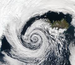
Pre-monsoon cyclonic activity in both the Bay of Bengal and the Arabian Sea is increasing. The Bay of Bengal generates almost 80% of cyclones in the India Ocean and the most of them in November. The Arabian sea is a bit more complicated because the south west monsoon westerlies and wind shears are much stronger. The westerlies also sweep in dust and pollution, and one hypothesis is that the pollution is making cyclones stronger.
Usually, the monsoon is the big monster that comes and squashes cyclone formation- this is why you only see cyclones pre and post monsoon- but since the mid – 1970s, the onset of the monsoon has been delayed. Combined with warming in the Arabian sea, that may be allowing cyclones to occur later in the season. In the last few years we have seen a number of pre-monsoon cyclones in late May to June. Cyclone Vayu last year was Interesting because it came around June 8, and the monsoon then did not happen until June 25. This is year the monsoon was supposed to come June 5, and one wondered whether Nisarga would delay the onset, but the storm pulled the trough over Kerela. Post Nisarga, will the monsoon continue to march north or will it stall or do something else? We’ll have to watch carefully. So the story has become quite complicated. The basic elements are still there but they are all behaving differently and interacting. The interplay of monsoon and cyclone is new.
Globally, as well as in Indian ocean, we see that over the last 40 years the umber of cyclones is not increasing- but they are getting stronger. Both Nisarga and Amphan intensified in a short time. This is called rapid intensification and is related to ocean warming and thus having more energy and moisture. If oceans warm, there is more water to feed a storm. Plus the atmosphere is also warmer. So the furnace of these cyclones is getting fired up rapidly. The unusual hit on Kolkata and Mumbai in the same season is worrying when you continue it with the fact that in the last five years there has been a large number of strong cyclones. We have to see if these are freak events or will continue. The conditions are certainly conducive: The Arabian sea is warming much faster than other oceans. The Bay of Bengal is already a warm ocean. Its a strong convective region which means the ingredients for cyclone0genesis are always there. We are just adding more spice in terms of warming.
In our study, we took census data on income, electricity, caste, employment, etc., and created an index, and compared it to how people fared during hazards. Surprisingly, we found good news. Although hydro-climatic hazards are increasing, mortality from those hazards declined in the period between 2001-2011. So the system’s response has improved. but, incomes have also gone up, employment has become more stable- although the lockdown may have changed that- and women;s education has improved. Women who are educated are better able to respond to government warnings. Socio-economic vulnerability to hazards actually declined in that decade.
In general, disaster management has gotten much better, although some last-mile issues remain with forecasting. Who is taking IMD’s warnings to the neighbourhood level? That is where women’s education can play a role. On the broader issue of mangroves and reefs, coastal development is still not as careful as it should be, and urban drainage systems are not adequate. As you go inland, deforestation and land degradation play a role in vulnerability. Policies have to take into account that may be cyclones are getting stronger and coming to regions they did not come to before. Some kind of holistic approach is needed.
Matter referenced:
Raghu Murtugudde, a Climate Scientist, University of Maryland, and a visiting Professor at IIT Bombay; Times of India, Ahmedabad, Sunday, 7th June, 2020.
By: Dr. Bhawana Asnani.
Happy to see Reviews, Additions, Suggestions and Comments, further.

Leave a Reply
You must be logged in to post a comment.